Predicting Extreme Weather Using Mobile Networks
St. Pölten UAS Research Project Explores New Method of Short-Term Weather Forecasting

Climate change has led to a significant rise of extreme weather events, as seen this summer. Weather forecasts in the very short term could help communities and individuals to better prepare for storms.
However, the necessary measuring stations are partly lacking. A research project by the St. Pölten UAS is currently investigating whether data from mobile networks could be used to enable localised and temporally accurate short-term predictions of extreme weather events.
Short-term weather forecasts that are as accurate as possible in local and temporal terms (up to a maximum of 12 hours) allow for the implementation of appropriate measures to prevent damage and enable communities and emergency forces to react more efficiently and better prepare for these events.
Short-term predictions require a dense network of measuring stations for the provision of up-to-date weather data. Such measurement data can be sourced from ground-based stations or remote sensing systems such as weather radars or satellites. In large areas of Austria, however, there is only a small number of ground stations due to the rough terrain and for certain regions, radar data is limited due to topographical reasons.
Weather Forecasting with Mobile Network Data
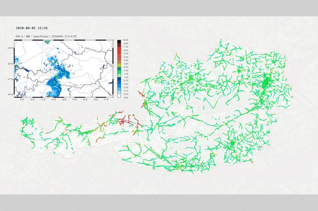
A research project at the St. Pölten UAS explores whether physical data from commercial microwave link (CML) networks such as signal attenuation can be used to predict extreme weather events and calculate precipitation data. “This would be a tremendous advantage in future. After all, it would enable appropriate measures to minimise damage, and we could react and plan more efficiently”, explains Project Lead Oliver Eigner from the Institute of IT Security Research at the St. Pölten UAS.
The continuous extension of CML networks has generated large amounts of data about the physical properties of radio transmissions over large areas. Network operating companies routinely measure these properties (e.g. signal attenuation) in order to guarantee network quality.
Within the framework of the project, precipitation data and microwave data pertaining to the storms in July and August are currently being evaluated as well. Based on this analysis, the project team strives to assess whether the mobile network data can serve to improve weather forecasts.
Project team members are the St. Pölten UAS, the Zentralanstalt für Meteorologie und Geodynamik (ZAMG) which is responsible for processing the measured data in the analysis and prediction models, Hutchison Drei Austria GmbH, and Amt der Steiermärkischen Landesregierung, Abteilung 14 – Wasserwirtschaft, Ressourcen und Nachhaltigkeit, Referat Hydrographie.
Project “LINK – Analysis and Nowcasting of Extreme Weather Events Using Data from Radio Links”
The project is funded by the Federal Ministry of Agriculture, Regions and Tourism (BMLRT) through the Austrian Security Research Programme KIRAS within the framework of the Austrian Research Promotion Agency (FFG).

Dipl.-Ing. Oliver Eigner , BSc
Coordinator AI and Digital TransformationService and Competence Center for Higher Education Development and Quality Management Researcher IT Security (BA) Department of Computer Science and Security